Thursday, December 6, 2012

Glacial Movements creating the beautiful landscape of Northern Minnesota

In Physical Geography class we have been learning about the different types of landscapes and I have determined that Minnesota was formed mostly by glacier movements. For the last two million years until about 10,000 years ago, the majority of the state was covered with ice sheets.

This is a lake that was created about 10,000 years ago, at the end of the last ice age, when the glaciers retreated from this area in Zimmerman, Minnesota.


About two million years ago, the 
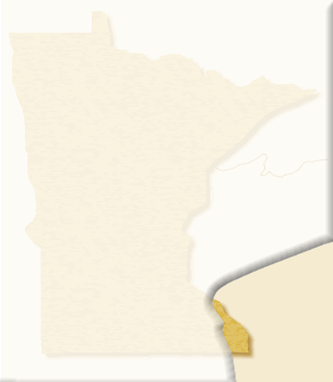
first ice sheet moved over Minnesota; referred to as the Nebraskan Ice Stage.

This is a picture of the Nebraskan Ice Stage covering majority of the state of Minnesota.


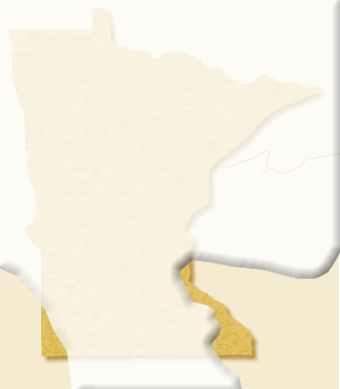
During the Kansan Ice Stage, about 400,000 years ago, another ice sheet moved over the state which left a layer of glacial till that was about 50 feet thick. Glacial till is a mixture of boulders, gravel, sand and clay that is left behind as the glacier retreats from an area.

This is a picture of the Kansan Ice Stage covering the state of Minnesota.


This is an excellent example of the till that a glacier created while moving through this landscape.


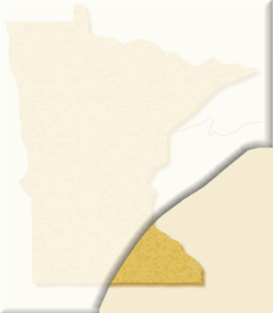
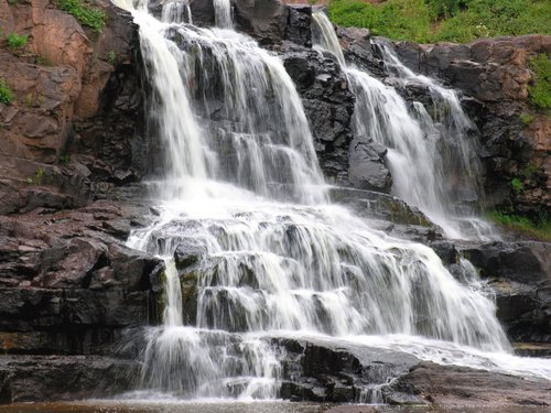
The next glacier period was referred to as the Illinoian Ice Stage which occurred about 150,000 years ago. This ice stage is responsible for creating the moraines that you see in south-eastern Minnesota. A moraine is a ridge of glacial till that was left by the glacier; the hills that you see today are comprised of this.

This is a picture of the Illinoian Ice Stage covering the state of Minnesota.

This is a great example of a field of moraines left behind the glacier's path
http://vervoortantarctica.blogspot.com/2010_12_01_archive.html


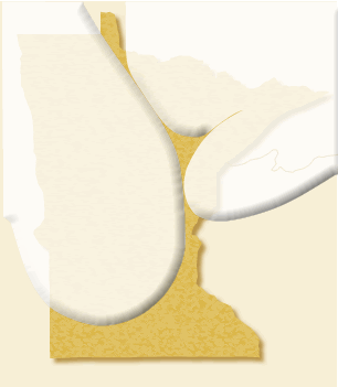
The most recent glacier to move over Minnesota, the Wisconsin Ice Stage, lasted about 90,000 years and ended approximately 10,000 years ago. The majority of the landscape we see today was formed by this ice sheet. There was a huge field of drumlins created in Northern Minnesota. A drumlin is a line of glacial till that is shaped like a tear drop with the pointed end showing which direction that the glacier was moving.

This is a picture of the Wisconsin Ice Stage covering the state of Minnesota.


This is an beatiful example of many drumlins.  You can see the tapered end on the left side of the picture that shows you where the glaciers moved into the area from. 


The Earth is currently in an Ice Age that began about 2.5 million years ago. Within this current Ice Age many cycles have occurred, they are known as glacial and interglacial periods. Glacial periods are typically colder temperatures and the expansion of ice sheets in the Northern and Southern hemispheres. Interglacial periods are typically warmer temperatures and the reduction of the ice sheets.  The intervals between glacial and interglacial periods can be anywhere from 40,000 to 100,000 years apart.

In the next 1,000 years...

We will still be in an interglacial period.  Temperatures will have continued to rise resulting in the glaciers melting significantly which will cause a substantial rise in the sea level. The rise in sea level causes a rise in the stream base levels as well so our rivers will have begun to flood, filling in the river valleys. We will no longer be the land of 10,000 lakes; we will be more like the land of 1,000 lakes because of the lakes will begin merging to form one huge lake instead of many different little ones.

An illustration showing us a futuristic view of what the rise sea level could succumb to.
 
A "funny" take on the effects of rising sea level.
 

Minnesota's overall landscape will begin to migrate north. The coniferous forests will move north because of their liking for a colder, arctic climate region. This will result in the prairie lands moving north because now they will be able to survive in these regions where they could not before.

This is a picture of the current beautiful coniferous forests in Northern Minnesota that will move north.
 
This is a map of Minnesota showing the current types of vegetation that occupy the state; in 1,000 years the praire grasslands will move over majority of the state.


In the next 100,000 years...

Scientists believe that cycles between glacial and interglacial periods last anywhere between 40,000 to 100,000 years.  Minnesota will be in another interglacial period but we will have gone through a glacial period so the landscape will be different.

The rivers will be cut deeper from the glaciers moving through the state. The hill's that are currently a part of the landscape will become more like foothills; the glaciers will cut back the land in the low lying areas at the base of these foothills.

This is how the Mississippi River could look in 100,000 years, a much more defined river by the glacier movements. 
 
 
The current hills of Minnesota's landscape will become more defined as the glaciers move through the state. 


 In the next 1,000,000 years... 

Minnesota will look dramatically different because the landscape will have gone through many different glaciation and interglaciation periods. We will be in a glaciation cycle in the current Ice Age.

A comedic look at how the world would look in an Ice Age.

Minnesota will be covered with a sheet of ice.

The vegetation of Minnesota will have gone back to being majority dominated by coniferous forests almost no other plant life will be able to survive this climate.  The animal life will have changed to only those that can survive the cold, arctic climates.

An example of the landscape of Minnesota in 1,000,000 years looks cold, frigid and baron.


References:

Tuesday, November 13, 2012

The Climate and Storms that occur in northern Minnesota


The state of Minnesota is located right at the 45th line of latitude; halfway between the North Pole and the Equator. It is positioned right in the center of our continent.

With the exception of the areas surrounding right around Lake Superior, the state experiences the continentality effect; which occurs in regions with an "interior remoteness" from an ocean. With the continentality effect influencing our weather we get extreme fluctuations, our summers are very hot and winters are very cold with an overall average amount of precipitation.

http://www.brainerd.com/falltours/images/fall-foliage-minnesota.jpg.jpg
This is a great illustration of how vibant the fall colors are and also my favorite season.


Fall in northern Minnesota...

With the jet stream strengthening itself from the weakened summer one; the nights get cold and frosty which begin the process of the leaves changing color. October temperatures tend to be around the mid-40's and usually some amount of snow will fall in October.

http://www.captureminnesota.com/photos/442063
Fall in Northern Minnesota


Precipitation in Minnesota during the fall...

Storms significantly die down and precipitaion occurs in the form of rain and sometimes snow.


http://www.climate.umn.edu/img/normals/81-10_precip/81-10_precip_norm_06-08.htm
A map of the state showing a normal distribution of precipitation throughout the state during the fall.

Winter in northern Minnesota...

Minnesota is known best for its frigid winters, the jet stream is now much more powerful.  With the different air masses colliding over the state which causes extreme and fast changing weather to occur. Blizzards also occur which bring massive amounts of snow with them. The average temperature is around 20 degrees.

http://images.wildernessinquiry.org/web/58355_web.jpg
Winter in the boundary waters


Precipitation in Minnesota during the winter...

Usually falls in the form of snow but can also can also occur in freezing rain or sleet.


http://www.climate.umn.edu/img/normals/81-10_precip/81-10_precip_norm_12-02.htm
A map of the state showing a normal distibution of precipitation throughout the state during the winter.


Spring in northern Minnesota...

The biggest threat is flooding from the snow and ice melting, which can cause erosion and weathering to the landscape. 

http://packsackcanoetrips.com/blog/wp-content/uploads/2011/04/DSC00710-21.jpg-no-11.jpg
This is a great example of Spring in the boundary waters, it shows how the snow melt can really affect the water flow of the surrounding rivers.

Precipitation in Minnesota during the spring...

Occurs in the form of rain, snow, sleet or hail.


http://www.climate.umn.edu/img/normals/81-10_precip/81-10_precip_norm_03-05.htm
A map of the state showing a normal distibution of precipitation throughout the state during the spring.

Summer in northern Minnesota...

With the weakening of the jet stream the summers are much more stable than the winters when it comes to the temperature. July is typically the hottest month with averages in the upper 70's but there have been years when heat waves move through the state and bring the temperatures to 100 degrees and higher.

http://epod.usra.edu/.a/6a0105371bb32c970b01310fd248dc970c-750wi
Summer in the boundary waters

Precipitation in Minnesota during the summer...

Falls in the form of rain and hail.


http://www.climate.umn.edu/img/normals/81-10_precip/81-10_precip_norm_06-08.htm
A map of the state showing a normal distribution of precipitation throughout the state during the summer.

During the summer, there is a lot more moisture in the air; due to the fact that warm air is able to hold more moisture than cold air. Thunderstorms are very common since we are at an intersection of a lot of different air masses coming together and the higher amounts of moisture in the air. During the updraft cumulus stage of a thunderstorm there will be huge cumulonimbus clouds that form in the sky.

A great example of cumilonimbus clouds preceeding the mature stage of a thunderstorm over Lake Ely, MN.

During the mature stage of a thunderstorms is where heavy rain, hail, thunder, lightening, strong winds and tornadoes will occur.

This is a great example of forked lightening during the mature stage of a thunderstorm in northern Minnesota.

In northern Minnesota this is golf ball sized hail fell during the mature stage of a thunderstom.
This is a funnel cloud approaching Gull Lake, MN.


References:

http://www.dnr.state.mn.us/climate/faqs.html

http://www.dnr.state.mn.us/young_naturalists/weather/index.html

http://climate.umn.edu/doc/online_resources.htm

http://climate.umn.edu/pdf/climate_of_minnesota/comV.pdf.

htp://en.wikipedia.org/wiki/Climate_of_Minnesota#Autumn

http://clasfaculty.ucdenver.edu/callen/1202/Climate/Weather/Weather.html

http://clasfaculty.ucdenver.edu/callen/1202/Climate/Cyclones/FrontsCyclones.html


Thursday, October 11, 2012

Hydrology of Northern Minnesota

 
http://blog.gmedical.com/Locums-for-a-Small-World/bid/34958/Minnesota-Land-of-lakes-loons-and-locum-tenens

We all know Minnesota as the Land of 10,000 lakes.  So what does that entail for the water ways and water systems of our state?  In this blog I will be explaining some basic Hydrology concepts and how they apply to Northern Minnesota


http://www.lodgeofwhisperingpines.com/outfitting1.html


You may have thought to yourself so where does all the excess water go? We all know that it does not just sit on the surface but instead it filtrates into the ground because it is a permeable surface. Ground water is the water that sits below the surface of the land and that fills in the spaces between the rock and sediment. When talking about how groundwater can be stored, there are two terms to know, porosity and permeability. Porosity is how the groundwater stores itself in between the rock grains, if there is a lot of space that means the ground has good porosity. Permeability is how well the pathways connect the pores to one another; if the pores are well connected it means that the ground has good permeability.


http://www.co2crc.com.au/imagelibrary2/storage.html
An example of good porosity


http://www.co2crc.com.au/imagelibrary2/storage.html
An example of good permeability


Today in our country we are having problems keeping the groundwater at a sufficient level. If we take more groundwater than the system is able to replenish itself, the process is called drawdown. The process of groundwater replenishing itself with precipitation penetrating the surface of the ground is called recharge. In most places of the world the levels of drawdown are greater than the levels of recharge when we need to attempt to keep the two levels at equilibrium. Groundwater occurs everywhere in the state of Minnesota. On average, Minnesota's groundwater provides about 75% of the state's drinking water and 90% of the state's agricultural irrigation water.

This map shows us how many centimeters per year of groundwater recharges back into the system


So now you may be wondering so where does all of the excess water flow to? The answer is a drainage basin which is also known as a watershed. A watershed is a body of water that all of the excess groundwater, precipitation and overflow drain into. Another component of a watershed is observing all of the rivers and streams in a particular area and seeing where they drain into. In Northern Minnesota the two main basins are the Red River of the North and the Rainy River Basin. So all of the little streams and rivers, which are called tributaries, groundwater, overflow and excess precipitation end up flowing into these two particular rivers.
 

http://www.30lakes.org/Images/basinsMN.jpg
This map explains to us all of the major watersheds in the state of Minnesota.


I hope this blog helped you understand a few of the main concepts of Hydrology and how they apply to Northern Minnesota!!!!

http://www.flickriver.com/photos/postndakota/227926099/


Sources:

http://www.dnr.state.mn.us/groundwater/index.html

http://www.co2crc.com.au/imagelibrary2/storage.html

http://clasfaculty.ucdenver.edu/callen/1202/Battle/Destroy/Hydrology/HydrologyBasics.html

http://blog.gmedical.com/Locums-for-a-Small-World/bid/34958/Minnesota-Land-of-lakes-loons-and-locum-tenens

http://pubs.usgs.gov/fs/2007/3007/

http://www.30lakes.org/Images/basinsMN.jpg


Thursday, September 20, 2012

Minnesota's Intrusive and Extrusive Rock Compoosition....


'Midcontinent Rift'

About 1.1 billion years ago, in the middle of our country today there was a divergent plate tectonic interaction that caused the crust of the Earth to begin splitting apart and magma from deep inside the Earth to come up and fill in the split. This interaction results in a huge basin that might become an ocean; in Minnesota's case we got Lake Superior.


This map explains shows you where the 'Midcontinent Rift' occured
http://prophecyfloodmid-continentriftsystem.blogspot.com/


Basalt

All along Lake Superior's shoreline you can see Basalt, which is an extrusive, igneous and mafic rock. An igneous rock is one that was formed from the cooling of magma and extrusive means that the rock formed on the Earth's surface. Basalt is comprised of mafic minerals, mostly Iron and Magnesium, which tend to be very dark in colors. The massive amounts of basalt in Northern Minnesota is due to when the 'Midcontinent Rift' occurred the massive amounts of magma that came up to the Earth’s surface, forming much of the landscape we see today.
Here is a picture of Gooseberry falls, the basalt is all behind the waterfall
http://www.planetware.com/i/photo/gooseberry-falls-state-park-two-harbors-mn160.jpg


Gneiss 

About 3,600 million years ago, Gneiss, a metamorphic rock was formed through the heating and pressure from the Earth from the parent rock, granite. Gneiss has crystals that are very coarse in grain size which tells us that the magma that formed this rock cooled very slowly. Gneiss is a foliated rock, which conveys that the minerals are aligned because of the massive amount of pressure they endured. 
This is a picture of Morton Gneiss, a rock prevalent in Northern Minnesota


Granite

Granite is a rock that is found mostly in northern Minnesota. Granite is an igneous, intrusive and mafic rock. An igneous is one that formed from the cooling of magma; an intrusive rock is one that cooled very deep inside the Earth. A mafic rock means it is lighter in color and it consists mainly of Silicon and Aluminum; Minnesota’s granite is mostly comprised of feldspar, quartz and mica.

Here is an example of Minnesota granite in it's natural state


Another picture of Lake Superior's Split Rock Lighthouse


Sources:


Wednesday, August 29, 2012

Introduction


Hello!  My name is Emily Larson and I am a student at University of Colorado: Denver.  I am currently working towards recieving my degree in Secondary Eduation with an emphasis in Science.  This semester I am taking Introduction to Geography and we have been instructed to create a blog.  So I have chosen to write my blog on an Introduction to Northern Minnesota's (specifically the Boundary Waters) Physical Geography. 


Why Minnesota you ask?  Well I am from Minnesota and have always loved going up North.  Every Fall my dad used to take my sisters and I up to Northern Minnesota and out of all the places we would go, my favorite place is the Boundary Waters.  It is one of the most beautiful and serene places in the world, well at least in my opinion!  The Boundary Waters is a one million mile canoeing, fishing, hiking, exploring and seeing nature area, its absolutely amazing.  By chosing this area for my blog I really hope to learn about the geographical features this place has and help me to understand even more of why I love this place so much.